This hike is located in Victoria's Alpine National Park and starts at Eight Mile Flat on the Howqua River, travels over the ridge to Eight Mile Gap and then down to the Jamieson River and then up to Mt McDonald. It then follows the Australian Alpine Walking Track to Mt Howitt and then heads down to the Howqua River via West Peak and returns to the starting point via the Howqua River. This trip would normally take me four days.
Bushfires, floods and man made changes can change the terrain described in this article drastically. This article is a guide only. Make sure you have the latest map and a compass or GPS. You should also have a Personal Locator Beacon and equipment adequate for a hike in the wilderness. Make sure you are prepared for snow which can happen on the range at any time of the year.
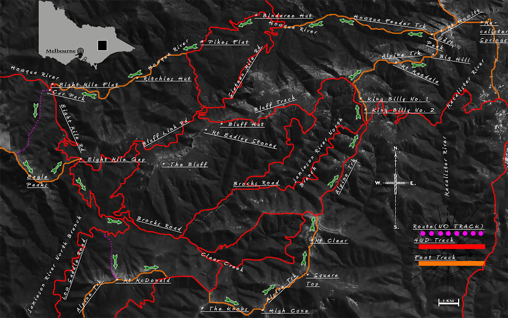
The map used in this article was: SVmaps "Buller - Howitt Alpine Area". 2nd Edition. 1:50 000. This guide was written in 2011. Amended 2016.
There are a number of different ways to do this hike. But in this article I will describe my favourite way which allows you to do a round trip from the Howqua River up to Mt McDonald (and there join up with the Alpine Track) and then on to Mt Howitt to return by walking downstream back along the Howqua River.
You can leave your car at Sheepyard Flat or at any of the other camp sites further along the Howqua River. But I usually leave my car at the little car park (no more than three cars) at the turn off to the Eight Mile Flat camp site. You can get there in a two wheel drive car but be careful as the unsealed road is narrow and high in places. The car park is opposite the gate to the little road that goes to the camp site and is at grid reference 491 823. If there is no room at the turn off you can go down the little road and ford the small creek and leave your car at the actual camp site (there are pit toilets there but the camp sites can be pretty crowded in the summer). There is also some spaces for cars just in front of the ford, if you don't want to cross the creek. There are camp sites on both sides of the little creek if you arrive late and want to camp before heading off the next morning. The gate at the top to Eight Mile camp site is closed in the winter.
There is a log/intentions book that can be filled out where the foot track begins at Eight Mile camp site (you can see it straight ahead of where you cross the little creek to get to the camp site). You will be coming back along this foot track – so it's a good idea to fill it out with the names of your party, car rego, route and when you expect to return. But ALWAYS leave your details and itinerary with someone dependable as these log books are not checked unless you are reported missing. Also remember to sign out when you return.
From where you have parked your car, you need to head south along Brocks Creek Road. This will take you up to Eight Mile Gap. This is an unsealed road rather than a four wheel drive track. It has a few hairpin turns as you get higher and keep your eyes and ears open for vehicles using the road. It never seems to occur to drivers on bush roads that there might be people actually walking on their actual feet – so be prepared to dodge! Brocks Road does a number of winding hairpins so the gradient up to the top is relatively easy. But you can shortcut and use the old sections of the four wheel drive track that go straight up the spur. It is much rougher and steeper but also quicker. Although they are marked on the map they can be hard to see. The first one (which is the roughest and most beaten up section) starts where Brocks Road crosses a little creek. As you head down the little slope to the creek you can actually see the old four wheel track as it climbs straight up the spur. Directly in front of this creek is some bushes and scrub. If you push through the scrub for a few metres you will see the old (very old!) four wheel drive track climbing steeply up the hill. This old track crosses Brocks road three times. After that you will have to follow Brocks Road proper. If you are coming down hill then you will find the top of this old track where Brocks Road stops following the side of the hill does it's first hairpin turn down the spur. It's virtually impossible to see at the top but once you push down for a minute or two you will pick it up.
If you feel like an adventure, there is an alternative way up to Eight Mile Gap. It's possible to climb the ridge immediately west of Brocks Road. From the back of the little car park opposite the gate to Eight Mile Flat you will see a pad on the right (as you face the car park from the road) that climbs up the embankment. (Ignore the more obvious old four wheel drive track on the left). This has recently (2016) been made a lot more visible by some idiot who has driven his 4WD up the pad before realising the pad goes no where. This pad fades out quite quickly but you want to be climbing the spur line that heads south, staying parallel to Brocks Road until it joins another, bigger, ridge that heads up to the main range. Once you reach the main spur line it is quite easy and open except for a few little scrubby bits towards the top. From where this spur line meets the main ridge - turn south east (make a left turn as you head up, in other words). There is a cairn here and this is also where you will meet up with the cut track that starts at Sheepyard Flat and follows the ridge to Eagle Peaks.
The big peaks ahead are Eagle Peaks. You go over or past three peaks. The last and highest one is 1446 metres high. From that peak make sure you head down to the eastern ridge which connects to the fairly broad 1296 metre hill and then turns sharply north/north east . The track is very clear but if you do manage to miss it, just head east/downhill. You will eventually hit Brocks Road). At the very end the ridge splits. Take the eastern/north eastern spur and it will take you straight to Eight Mile Gap and the junction of Brocks Road and The Bluff Link Track. Doing it this way is slightly longer and tougher. Another disadvantage is that there are three peaks above 1400 metres. Which means you have to go over them and then down to Eight Mile Gap. But it is a lot more fun.
From Eight Mile Gap, at the top, head down Brocks Road to the Jamieson River North Branch. If you need them, there are plenty of very pleasant camp sites along the Jamieson River. Cross the first road bridge you come to and travel up Low Saddle Road as it skirts Mt McDonald and the Great Dividing Range. After about a kilometre (as the crow flies but longer if you are walking the track!) you will come to an old and overgrown four wheel drive track on your left. You may see a few old camp fires here where people have camped before or after the ascent to Mt McDonald.
You then walk up the side of the spur and turn left (south east) when you get to the top of the spur. Don't bother continuing onto to where the road actually crosses the spine of the spur to start from there as it is very rough and overgrown. The path up to Mt McDonald is marked on the map I have used as a foot track but it is very faint and often just disappears. There is some very faded tape tied around the occasional branch and tree trunk to help out and you can occasionally make out where the old four wheel track was cut into the side of the hill but it really just an easy bush bash.
Don't worry if you miss the old track, just head for the saddle between the 1046 feature and the 1108 feature. From there you just head dead south up the obvious spur, towards the very obvious summit. You will have seen Mt McDonald from Low Saddle Road and spotted the spur you will be taking to the top. If you do miss the saddle – don't worry about it. Just make sure there is a slope to your east and west and that you are heading south. The way up is trackless but fairly easy. It gets steadily steeper and there are a couple of places where you will have to climb or sidle around small cliffs.
There are places you can set up a tent on the summit (but it is pretty exposed). If the weather is really bad you can take the Alpine Track and continue east along the ridge line. There are plenty of good spots to set up along the way that are more protected. The top would normally be where I would camp the first night.
Following the Alpine Track along the eastern ridge of Mt McDonald is quite easy. The ridge eventually splits. Keep following the Alpine Track down the sharply descending ridge to the east. The other split takes a sharp turn north (very easy to spot before you descend as there is a small saddle and then a sharply defined hill of 1429 metres on the northern spur). The eastern track allows you to descend off the Mt McDonald ridge to Nobs Track (a four wheel drive road). There is a small camp site where the Alpine Track meets this four wheel drive track. If you head down Nobs Track (west) for a kilometre or so you will find a small spring that crosses the track. But this spring is sometimes dry.
Continue east along the four wheel track for a couple of kilometres. Just before the track turns north and descends down to Clear Creek, you should see an Alpine Track marker and a cairn that indicates where the Alpine Track leaves the road and heads south through scattered trees and meadow to The Nobs. There is a little camp spot here as well. At the top of the 1495 metre hill the track turns east and follows the curves of the connecting ridge to High Cone. There are a couple of camp spots along the way here if you need them. If time permits, you might like to drop your pack and take a short side trip south west along the ridge line of The Knobs to where the view is much better.
Once you leave the connecting ridge and start climbing High Cone itself, it is worthwhile continuing right to the very top because there is a great view of Square Top and Mt Clear from the summit. But if you are feeling buggered you can just sidle north east along the fairly open northern slope of High Cone until you meet the saddle between High Cone and the cliffs of Square Top. This saddle is between High Top and the south western spur of the cliffs of High Top (marked at 1489 metres on the map). This saddle is broad and has many lovely spots for a tent – but no water. (If you are desperate and lucky, there is actually a muddy seep far down the slope on the eastern side of the saddle. It's used as a wallow by the local deer so it's not very palatable and I would boil it thoroughly. It is often dry in the summer).
From the saddle, head north east along the ridge to the very obvious 1489 metre spur. From there climb straight up to the top of Square Top. It is possible to take the alternate route that sidles under the small cliffs of Square Top. However rain, snow, bushfire and the heavy growth that follows these three, has wiped out virtually all trace of the low track (although it will probably be re cut one day). It is actually easier to climb to the top and walk along the edge of the cliff. The terrain at the top consists of very open snow gum thickets and soft grass.If you are interested, there is a good camp site on the eastern side of Square Top – with water, if it hasn't been too dry. There is also a very interesting walk down Macalister Spur to the Macalister River – but I'll save that for another article! But Mt Clear has better views. If you do want to camp on Square Top then walk south east along the edge of Square Top until you come to a large alpine meadow. Look down hill and you will see the meadow turns into a little valley with a small rise on the right. Head down the valley for a minute or two and you should find some little pools that then become a spring. Sometimes you have to continue all the way to where the gully descends downwards and plunges over the cliff. But be aware that this water is not totally reliable in summer.
If you continue to Mt Clear you just need to walk down to the saddle on the north side of Square Top and head dead north up to Mt Clear. This lovely mountain is one of my very favourite places. Not just because of it's beauty but because there is water only minutes away from the summit. I would normally camp here on the second night.
The summit of Mt Clear is a broad, rocky plain. As the track is just about to reach the top and curves over to the right (east) you will see a faint track on your left (that heads west). Follow this track for about a minute and you will come to a seep. There is usually a trickle that will let you (slowly) fill a billy as it trickles over muddy ledges and roots. If there isn't a trickle you may need to dig a hole in the mud and let it fill. I'm puzzled as to how a seep can exist literally a stones throw from the very summit but it is very reliable and I personally have never seen it go dry. There are places you can pitch a tent near the seep. Or you can just fill up and head on to the top. The summit is two broad hills joined by a broad saddle. So there is plenty of large meadows or sheltered forest glades to pitch a tent in.
Head north from the summit (which is marked by a large cairn). This will take you over the saddle to the second (northern) summit. Follow along the top of the cliffs on the eastern side until you reach the descent down the north eastern spur. You then head down the fairly gentle slope of the north eastern spur (you can see the road below from the top) until you reach the clearing and Clear Creek Track (which is part of the Alpine Track). Continue north. There is water at Chesters Yard, about 2 or 3 kilometres further on. But it's used for watering horses so I recommend boiling it. Eventually you will come to a crossroads where the track you are on meets up with Brocks Track and King Billy Track. Head north west up Bluff Track, passing King Billy No. 1 and King Billy No. 2 on your right.If you like you can follow the Alpine Track and cross King Billy One and King Billy Two. Or you can just take it easy and follow Bluff Track road until you get to the turn off for Mt Magdala (which is posted with an Alpine Track marker). There are camp sites at the turn off.
But! If you follow the old and faint four wheel drive track that heads off from the camp site/clearing beside Bluff Track in a vaguely eastern direction (it quickly becomes a foot track and then fades away completely) you will find more camp sites. You will also find seeps and if you go far enough, a little spring. There are a whole series of lovely little, verdantly green clearings that have been lovingly “mown” by the local animals and they make wonderful, sheltered and quiet tent sites.
From the same clearing next to the Bluff Track, follow the Alpine Track and head down the north east spur that joins up with the saddle below Mt Magdala Keep following the track up to the top of Mt Magdala and down the other side. There is another track that passes under the cliffs of Mt Magdala on the south side before rejoining the track on the other side of the peak. It is easier and does give you great views of the cliffs of Mt Magdala up above but I prefer going over the top myself.
There is a good series of camping spots on the saddle on the other side of Mt Magdala and this is where I would normally spend my second night. If you look carefully on the north side of the camp site, you will notice that there is a faint little foot track that heads down and parallel to the track – heading towards the steep, bush covered slopes of Mt Magdala. Eventually this take you to a tiny little spring where you can get water (but in a dry summer this can disappear).
From the camp site, continue along the obvious ridge and the well defined Alpine Track towards Big Hill. From there head onwards to Mt Howitt. You will notice West Peak, the secondary summit on your left just before you get to the top of Mt Howitt. The track you can see that goes to West Peak is your route down to the Howqua River.
Mt Howitt has a very broad and totally open summit. The summit is simply the highest point of a large alpine plain. In fine weather the way is very obvious but in cloud or fog, try and stick close to the edge of the cliff. Eventually you will come to a small group of low rocks. One of those rocks has a Survey Service marker the size of a large coin on it. You are standing on the top of Mt Howitt. At 1742 metres this is the highest point of the entire trip.You have a choice here. From the summit of Mt Howitt head east across the gently sloping plain (still following the Alpine Track) to the edge of Howitt plateau. You can then detour away from the Alpine Track and head across the obvious ridge to the east and spend a night at Macalister Springs. There is dependable water there, plenty of camp sites, a pit toilet and Vallejo Gantner Hut (the loveliest hut in the Alpine National Park.) The track to McAllister Springs is very clear, as is the Alpine Track (which is also signposted.) The walk to get to McAllister Spring takes about 45 minutes from the summit. You may want to boil the water at the spring – horses are watered there (although I often don't). But the detour will add an extra day to the trip.
If you do not want to bother with Macalister Springs then you need to turn around and head back the way you came. Make for West Peak (the western spur of Mt Howitt) and follow the Howqua Feeder Track as it heads west down the spur to the headwaters of the Howqua River. There is a clearing at the bottom you can pitch a tent in and you no longer need to worry about water as you will be next to the river for the rest of your trip.There used to be a four wheel drive track and bridges that took you all the way to the camp site at the bottom of West Peak Spur. But the bridges at the top of the river are gone now and the track is rough in places (but easy to follow) and you will need to ford the river a few times. It becomes a proper four wheel drive track when you get to Bindaree Road. There is a popular camp site and picnic ground for four wheel drivers at the cross roads (all of the camp sites from this point on are heavily used by four wheel drivers) and it has a pit toilet. You continue down the track to the huge river flat at Bindaree Hut (you have to ford the river – there is no bridge.) The hut is picturesque but tiny and it leaks. But there is plenty of room to set up a tent and also a pit toilet. I would normally camp here on the third night. Or maybe continue to Ritchies Hut.
The next hut along the river is at Pikes Flat. It is missing some walls and is usually in use by four wheel drivers but does have a pit toilet. This too has plenty of room to set up and the river is big here and is a great place for a swim in the summer.Keep going along the four wheel drive track until you get to Sixteen Mile Creek. Here the four wheel track (Sixteen Mile Creek Track) heads away from the river and makes its way up the hills to Bluff Track. There is a well defined, posted and popular foot track that continues west along the Howqua River. Eventually you will come to Ritchies Hut which is located beside the junction of Fourteen Mile Creek and the Howqua River. Like so many other huts in the area, this hut was burnt to the ground by bush fire and the one you see now is it's replacement (which itself was a replacement for an earlier hut and so on and so on). It is a well built hut but I would feel sure that it has some resident wild life that would make sleeping difficult. But if it is very wet and cold it is dry and does have a fireplace. There are lovely places to set up a tent around the hut and there is a pit toilet up the hill behind the horse paddock next to the hut.
The foot track continues along the valley. Sometimes climbing quite high above the river. It's a pleasant walk and you can see the remains of gold mining shafts along the way. Eventually you will come out at the Eight Mile Flat camp site where you have left your car (or keep going until you get to where your car is.) Just a few hundred metres before you get to Eight Mile Flat you will see an old four wheel drive/foot track that climbs the steep hillside on your left. This is one way of getting to The Bluff and probably the most fun and I will be writing an article about that trip one day too.
If you have signed in at the log book – remember to sign out before you leave.